English
You can add several tracks, markers and map on the same article. You can customize the track, the markers and the map.
First map
Notre Dame des Neiges
Latitude: 44° 36' 02"
Longitude: 3° 56' 00"
Description
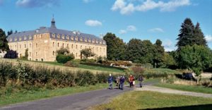
Notre Dame des Neiges Abbaye in Ardeche (GR7, GR72, GR70 Stevenson Path)
Stevenson trail step 1
Profile
No data elevation
Name: No data
Distance: No data
Minimum elevation: No data
Maximum elevation: No data
Elevation gain: No data
Elevation loss: No data
Duration: No data Description
From Cheylard l’Evèque to La Bastide Saint Laurent
Stevenson Trail Step 2
Profile
No data elevation
Name: No data
Distance: No data
Minimum elevation: No data
Maximum elevation: No data
Elevation gain: No data
Elevation loss: No data
Duration: No data Description
From La Bastide Saint Laurent to Chasseradès
Other example
It’s possible to choose the size of the map, the alignment, the tiles, ….
Go to the station
Profile
No data elevation
Name: No data
Distance: No data
Minimum elevation: No data
Maximum elevation: No data
Elevation gain: No data
Elevation loss: No data
Duration: No data Description
Go to the station by the paths