English
Please note that this is an old version of the site. It should be updated and complete at the end of December!
Lf Hiker is a wordpress plugin for quickly display your gpx tracks with their profile elevation on an interactive map.
Lf Hiker is reponsive and mobile friendly.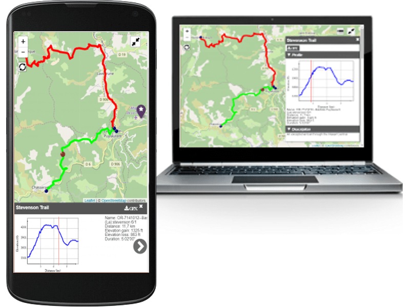
Main Utilisation
Simply upload your gpx file with the wordpress media manager, complete its informations and insert it in your post/page (shortcode).
Display the post/page : you have an interactive view of your track.
The trail is displayed on an OSM map by default, and have its own information window with:
- title
- description
- interactive profile elevation according to path
- distance of the track
- elevation loss
- elevation gain
- duration
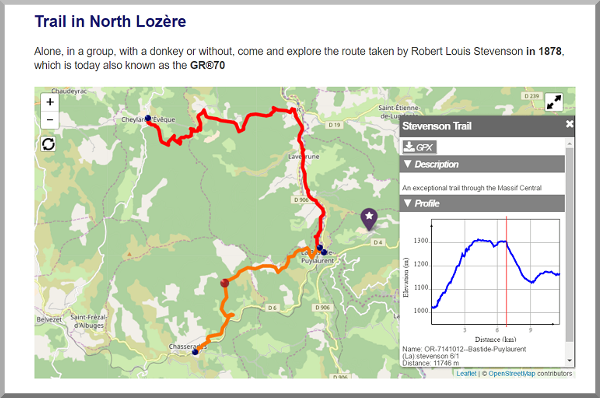
Lf Hiker plugin easily display gpx track and their profile elevation.
List of Features
Lf Hiker allows displaying too:
- few gpx files in the same map
- markers on the map
- few maps on the same post/page
For gpx track you can custom:
- title
- description
- stroke color
- stroke width
- distance unit
- altitude unit
Lf Hiker included an helper for edit map and add markers.
You can choose
- for the map :
- the tiles layer ( among OSM, OSM_FR , stamen watercolor, arcgis world topo)
- to display the fullscreen button
- the map’s view or let lf Hiker find automatically the best view
- to display the reset button
- to display the button “list of layers”
- the size of the map
- classnames for the map ( including your custom class)
- zoom on mousewheel
- for the markers
- color of icon marker
- symbol in the icon
- title
- popup
- visibility according to zoom or not
- independant window with large description
You can do all this with the helpers or directly using shortcodes
You can choose to unactive the helper.
Lf Hiker allows you to customize the css in admin configuration (colors of information window and selected path)
You can choose default units for profile elevation.
Supported languages
- Français (fr_FR)
- English (en_US)
If you need language for Lf Hiker which is not included. You can easily translate with poedit from the file :lf-hiker/languages/lfh-default.po.
I will be happy to add your translation to the plugin.
If you have any questions about the method, do not hesitate to Contact-me
If you find errors in my english translation do not hesitate to Contact-me.
Releases
1.13.0
- Add spanish language
…
1.3.8
- Add helper for the events
1.3.7
- fixed error on activation with PHP5.5
1.3.6
- smooth profile when lot of points
- profile with height difference minimum 40 meters
- fixed: characters not center in buttons list and fullscreen
- modify track name filter
1.3.5
- fixed : too long title for gpx or marker
- fixed : url gpx with special character trigger file not found error
- disabled : map first center on Paris
1.3.4
- fixed : https for tiles
- fixed : gpx url for https
1.3.3
- fixed : On small screens, for three buttons, the elements are not centered
- fixed : Conflict with the bootstrap themes on hidden elements
- fixed : list button too big
1.3.2
- default value attribute visibility set to always for marker
- update modules for gulp
- add icons and create files only with used icons
- fixed : color of the buttons is applied only to the first one on the large screens
- fixed : added unwanted tag p arround shortcode
- fixed : no event on button marker when only markers elements
- fixed : helper, button add marker no event (same issue than previous)
- fixed : title height issue with some theme
- fixed : only four buttons visible on small sreens
- fixed : mousewheel disabled on element window
1.3.1
- Issue title h1, h2, h3 style overwrite by lf-hiker
1.3
- Responsive
- Mobile friendly
- Add track duration
- Deactived Mapquest and cache
1.2.1
- issue map center on Paris when no title attribute in shortcode lfh-marker
- issue no map or map center on Paris conflict with AccessPress Instagram Feed
1.2
- Add foot for elevation unit
- issue for popup when click for a marker from list of elements
1.1
- Add picture for about page in back office
- Add miles distance unit for profile elevation
- issue when shortcode
[lfh-map ]without attributes
1.0.4
- issue when no mapquest key.
- loading asynchrone js and default intialisation for the helper
- readme file
1.0.3
first stable version